The last three weeks of our massive 6 month holiday will be spent along the Atlantic coastline of France, between La Rochelle and Le Havre and then inland to the cathedral cities of Chartres, Rouen and Amiens. At least that has been the plan. I am writing this blog in Honfluer, near Le Havre so we have come quite a long way since my last post about San Sebastian.
If you are geographically challenged, like most of us, can I suggest that you open Google Maps and enter France. Then click the + button once or twice until you get a map of all of France that shows San Sebastian, just inside Spain; La Rochelle, just above Bordeaux and Le Havre, directly under Brighton, England. Inland from Le Havre is Rouen and to the north east of Rouen and north of Paris is Amiens. Chartres is south-west of Paris and while it is on our plan, we might not make it.
From San Sebastian, which is only about 20 minutes from the French border we took the Autoroute north, past Bordeaux, to the town of Cognac. No prizes for guessing what this area does with its grapes.
Cognac has about 20,000 residents and is built on the left bank of the Charente river. The town is situated on one of the pilgrimage routes
to Santiago de Compostella and is home to a French Air Force training base.
It is 400 kilometres southwest of Paris.

This is the huge Hennessy distillery on the Charente river, in a very grey-looking Cognac.

La Rochelle is a lovely, easy going, maritime city with a large university and three ports - maritime, fishing and pleasure. The pleasure port is the largest in Europe. We spent a day watching work on extensions to the marina, three new yatchs being fitted with their masts, rigged and then dismantled, and the never ending movement of boats in and out of the water. Fascinating! The maritime port is home to France's submarines.

The old port area of La Rochelle is dominated by three 14th and 15th century towers that stand at the entrance to the old port
The oldest is la Tour de la Chaine (in the centre of the photo), so called because a huge chain was slung from it across to Tour St-Nicholas (right) on the other side when the entrance to the port was expanded in 1824. Just over 400 years ago the first settlers to Quebec left from La Rochelle and Tour de la Chaine now houses a permanent exhibition celebrating this.

Tour de la Lanterne (above) was originally built as a beacon for
ships but subsequently became a prison for pirates, enemy seamen including the
British, then Huguenots and finally clergy during the revolution. The only
surviving medieval lighthouse on the Atlantic coast, you can still see 600 or
so bits of graffiti inscribed on the walls by captured English, Dutch and
Spanish seamen and later, military prisoners.
Tour St-Nicolas, the tallest of the three, and once a formidable military building,
symbolises the power and wealth of La Rochelle at the height of its powers.
Forty-two metres high, the inside is a labyrinth of stairs and corridors.

For a city with a population of around 100,00, La Rochelle is very quiet, with loads of cyclists, loads of pedestrians and very few motor cycles.

And as they say "Welcome we speack approximate but ...... friendly englisch". Must have been translated by a German.

We had coffee at a bar at the end of the main retail strip. No, not at this bar. This is the TAB. Imagine our TABs if they were also a bar and a cafe.

Immediately off the coast from La Rochelle is an island called the Ile de Ré - the island of the king. Its main town is a pretty village called St Martin de Ré that has been settled since Roman times. The Ile de Ré, with a resident population of 15,000, is connected to the mainland by a 3 km bridge.

The bridge, together with a TGV (very fast train) link from Paris to La Rochelle, has seen the island become one of Frances most popular holiday resorts because it has the same amount of sunshine per year as the Cote D'Azure. We saw phenomenal growth and development since the first time we visited in 1998. No more the sleepy village with two shops, 3 restaurants and one hotel.

But St Martin de Ré was not always a sleepy village. In fact it was a citadel in the time when France and England were constantly doing battle.

In 1627 England invaded France by attacking St Martin de Ré. The battle lasted 3 months at which point England retreated.

These fortifications withstood that seige and others and today protect the fishing and pleasure boats in the harbour.
Leaving La Rochelle and the Charente-Maritime region, we headed further north to Brittany which is that bit of France that protrudes west, further into the Atlantic.

Our destination was St. Malo. You see it on the map north of Rennes, above Dinan. Mont Saint-Michel is a little further east.
 Dinan was a fascinating little place, well worth more than the few hours we gave it.
From our base in St. Malo, we explored the northern coast of Brittany, quite unlike anywhere else in France and inextricably linked to England, the English, the Channel and the sea.

Huge windswept beaches with great tidal change and beautifully preserved heathlands.

New lighthouses (18th C) next to old ones (13th C).

Ancient forts guarding the coast.

Gigantic daily 6 metre tides. Look how far the water rises up the posts on the marina.

The estuary of a small river when the tide is out. Kilometres of sand flats full of all sorts of shell fish and those who pursue them. The dark areas are rocks covered with seaweed. At centre left you can see thousands of mussel and oyster cages.

One of the main oyster growing areas is Cancale, only 15 kms east of St. Malo and on the edge of the Bay of Mont Saint-Michel. When we arrived it was low tide.

The oyster farms are vast and at low tide out come the tractors and other "farm" machinery to "plant and "harvest" as with any crop.

They seed the oysters in these wire pouches and hang the pouches from steel frames.

You can't get fresher than this - direct from the water to you. These women work their stalls seven days a week, all year round.

We weren't really well organised. We should have found the boulangerie for a fresh baguette, the mini-mart for a cold bottle of rosé and the wine glasses from the car - before we ordered two dozen of these huge, white Cancale oysters which we ate leaning on the rock wall. 7€ ($10) per dozen.

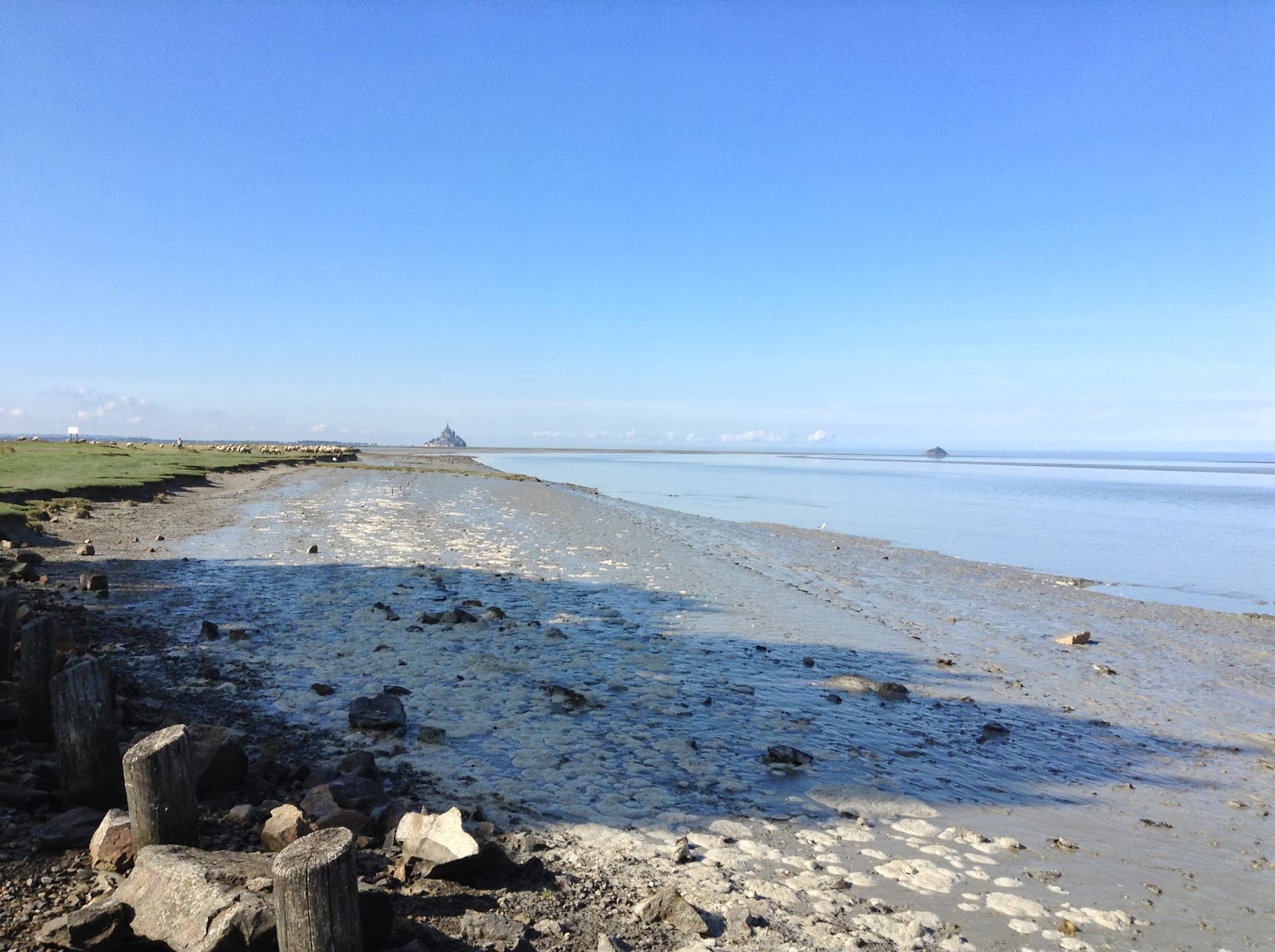
The oysters grow in this huge shallow bay called the The Bay of Mont Saint-Michel. Standing on the headland at Cancale I photographed this old sailing ship as it exactly crossed my line of sight with Mont Saint-Michel. You have to look closely, but it is on the horizon exactly behind the yacht and 50 km away to the east.

This was as close as we could get to Mont Saint-Michel. We had delayed our trip until the Monday, having been advised to avoid the weekend crowds, and as we were on our way to our next destination, we had all our "stuff" in the car with us. The only car parks are a long way from the shuttle bus point that takes you across the sand flats. After previous experience we were not prepared to leave our fully laden car in an unsecured area. I was very disappointed, not just because we couldn't actually visit the site, but because we could not get anywhere near it. Still, as a UNESCO site with 3.5 million visitors a year, I can understand the need for care.
"Mont Saint-Michel
stands in the centre of a huge bay invaded by the largest tides in Europe.
Situated at the border between Normandy and Brittany, between Cancale and
Granville, and covering 500 km2, Mont Saint-Michel bay is the largest area of
salt meadows and polders in France. It is distinguished by the exceptional
distance between high and low tide - up to 15 metres during spring tides. It
offers a wide diversity of natural environments, with exceptional fauna, flora
and light.
The tides in Mont
Saint-Michel bay are very impressive: covering a distance of almost 13 metres
on days of high tidal range, the tide goes out very quickly over some 10
kilometres, and comes in again just as quickly. The expression used is that it
"comes in as fast as a galloping horse".
Today, Mont Saint-Michel is
only surrounded by water becoming an island during the great equinox tides,
fifty-three days a year and for a few hours. In order to return it to its
original grandeur, major development work was launched in 2005 (new dam on the
Couesnon, dredging work, a road barrier and a car park), which will allow Mont
Saint-Michel to become an island once again by 2015."
Maybe I'll wait until 2015 before a return visit.
Viv, Its bad luck that you couldn't get to Mont Saint Michel, we stayed 2 nights there and it was one of our hilights from our trip. Watching the tide come in was just amazing, especially with people who were a bit too slow walking back from a close by island. We would visit it again when we go to France next time. Regards, Phillip & Paula
ReplyDelete